
Have Your Say
The draft concept design is open for community feedback.
Feedback closes Monday, 23 March 2026
Council is planning a new shared walking and cycling path connecting Mascot to Eastlakes. The project aims to create a more connected, accessible, and well-serviced transport network for the community.
The new shared path and cycleway will make Mascot safer and more convenient for people of all ages and abilities to walk and ride, supporting everyday short trips and encouraging more active travel.
The proposed route aims to improve:
To deliver these improvements, some changes may be required, including adjustments to on-street parking, the relocation of bus stops, and changes to school kiss-and-ride arrangements near schools.
Have Your Say - We want to hear from you. Your local knowledge is vital to shaping this project.
The draft concept design is open for community feedback.
Feedback closes Monday, 23 March 2026
Timeline item 1 - complete
30 June 2025 - City of Sydney publishes the 'Sydney Cycling Map'
Bayside Council consults the Sydney Cycle Map to inform potential Active Transport Corridor options for further investigation in the Feasibility Study.
Timeline item 2 - complete
Council conducts informal preliminary discussions with JJ Cahill High School and Eastlakes Public School
Timeline item 3 - complete
Council contacts transport providers
Council undertakes informal discussions with bus service providers operating along Maloney Street, George Street, and St Helena Parade. To identify major bus routes and bus zones.
Timeline item 4 - complete
Council contacts TfNSW and freight management teams
Informal preliminary discussions with transport operators regarding active transport planning, freight, road safety, and traffic management in the precinct.
Timeline item 5 - complete
September 2025 - Council conducts a Feasibility Study on Coward Street
Timeline item 6 - complete
Friday, 20 February 2026 - Feedback Opens
Timeline item 7 - complete
February 2026 - Council notifies local businesses of the community consultation for the proposed Active Transport Corridor
Council has distributed a letter to local residents to inform them of the community consultation.
Timeline item 8 - complete
Friday, 27 February 2026 - On-site engagement
POSTPONED: This event has been postponed due to weather conditions. Please keep a close eye on this page for further updates.
Come to Council's Lunar New Year Festival to view the plans and chat to our engagement team.
Timeline item 9 - complete
Monday, 23 March 2026 - Feedback Closes
Post exhibition, a report on the results will be considered by Council with recommendation on any design changes to finalise the feasibility and concept design report.
Timeline item 10 - active
Under review
Contributions to this consultation are closed for evaluation and review.
Timeline item 11 - incomplete
Final decision or outcome
Council applies for grants to continue with detailed design documentation in financial year 26/27. Council will determine an implementation plan as part of the detailed design phase.
Select the +Follow key at the top of the project page to be notified when this project is updated.
Timeline item 12 - incomplete
2028 - Construction is anticipated to commence
Will any speed limits change?
Council is not authorised to set or change speed limits. Speed limits are managed by Transport for NSW (TfNSW). While the proposed design changes may support lower vehicle speeds, any decision to amend speed limits would be made by TfNSW.
Will this project increase parking?
Based on the concept plan prepared, Council anticipates a reallocation of parking spaces leading to a net gain of 17 parking spaces.
Will there be impacts to existing parking?
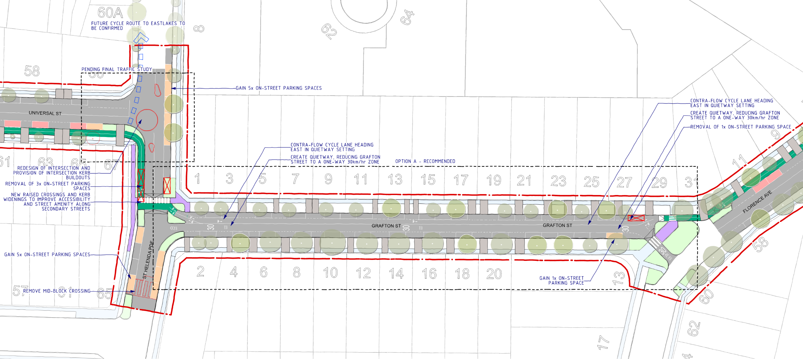
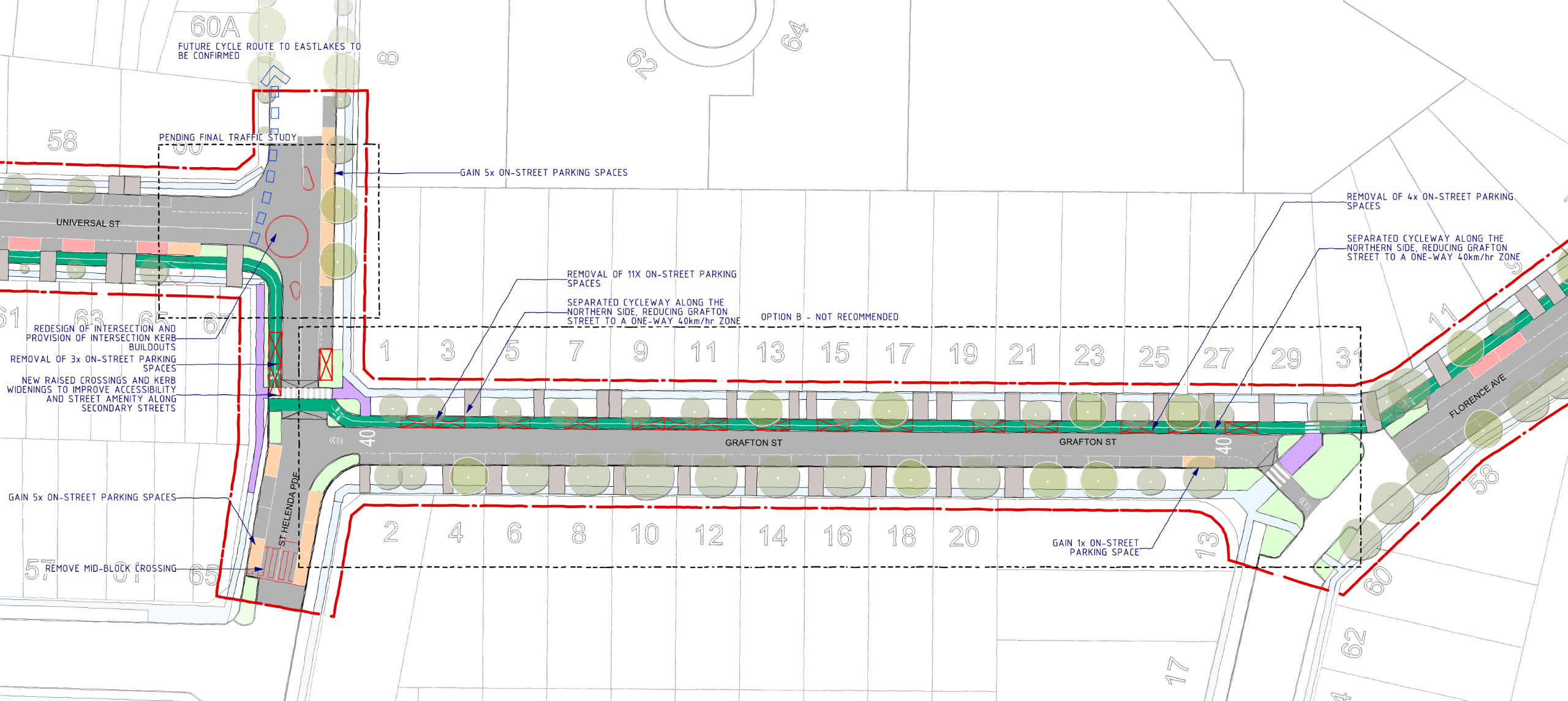
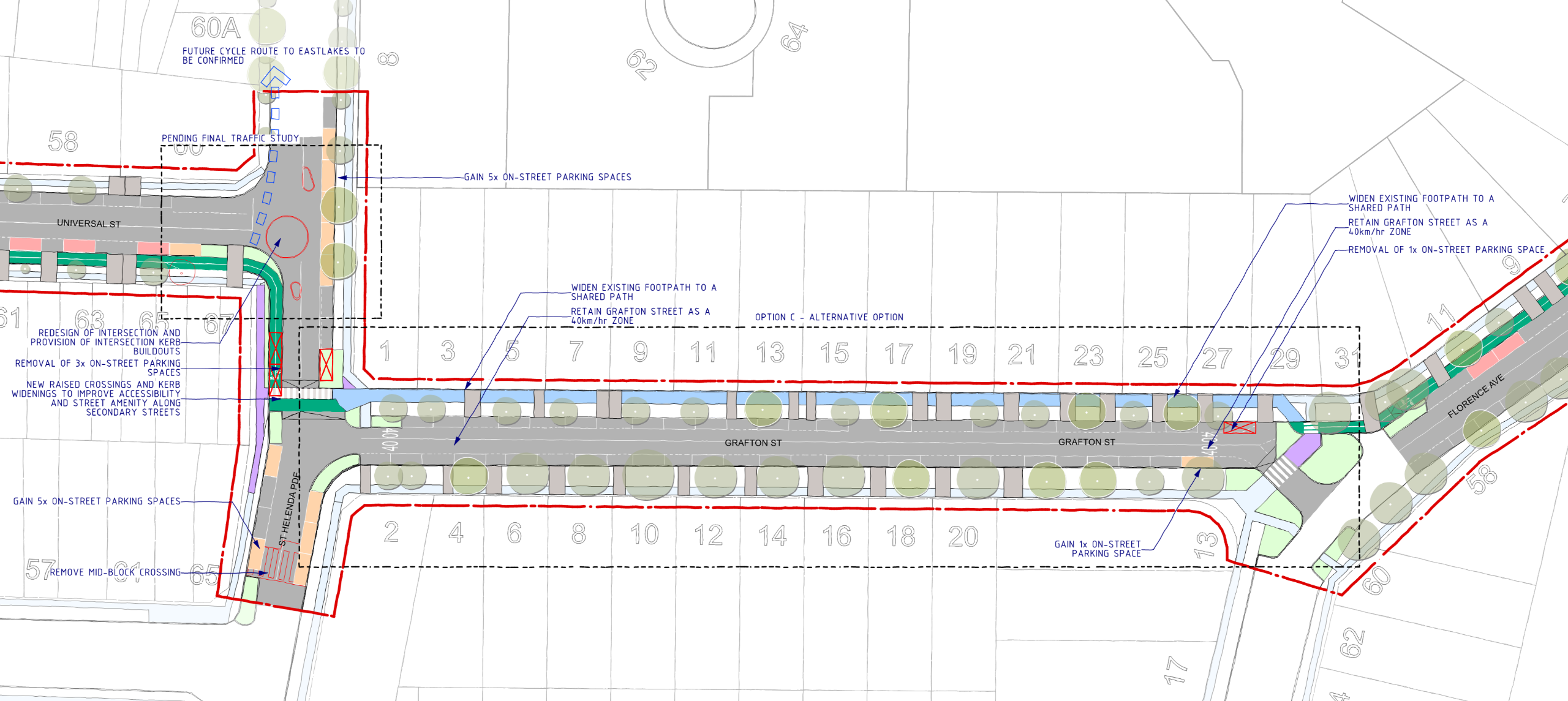
Some options do require partial parking removal to ensure safe widths for cycleways. These losses are minimised where possible and clearly quantified in the engagement materials. Residential streets are prioritised for parking retention, with trade-offs discussed transparently.
Parking losses have been minimised. The project will result in a nett gain of 11 spaces.
| MASCOT TO EASTLAKES CYCLEWAY ON-STREET PARKING | |||
| Existing | Change | Total | |
| O'Riordan Street | 0 | 0 | 0 |
| Coward Street | 224 | - 5 | 219 |
| Maloney Street | 1 | 0 | 1 |
| Universal Street | 61 | + 1 | 62 |
| St Helena Parade | 8 | + 10 | 18 |
| Grafton Street | 31 | 0 | 31 |
| Florence Street | 53 | + 5 | 58 |
| TOTAL | 378 | + 11 | 389 |
Extracted from page 4 of the feasibility report, the recommended route passes near several key education facilities, including:
In the broader study area, the investigation also considered additional schools and early learning centres, including:
This ensures the project considers the needs of children and families when planning safe and accessible active transport routes.
Following this public consultation, Council will review the outcomes and any recommended design changes to finalise the feasibility and concept design.
Detailed design is not currently funded and will be subject to community support, Council endorsement, and grant funding. Council intends to seek funding to undertake detailed design as early as 2026 (FY 2026/27), with an implementation plan developed during this phase.
Subject to funding, approvals, and coordination requirements (including TfNSW), construction is anticipated to commence in 2028.
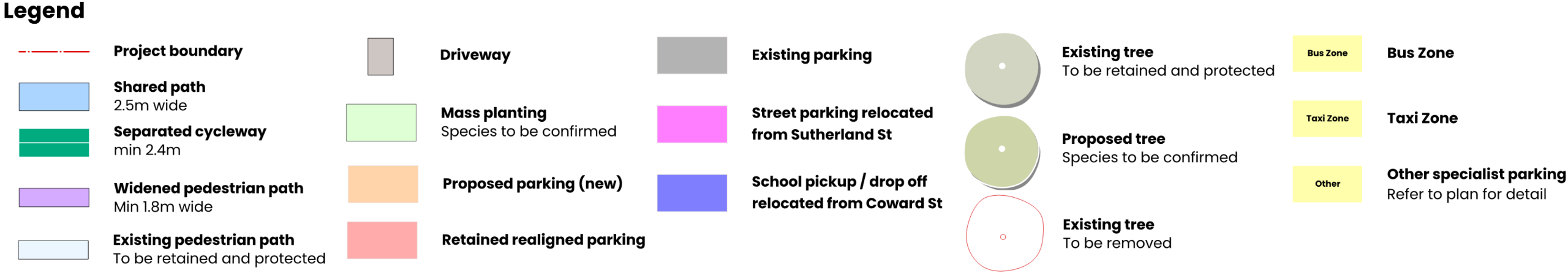
Shared paths
Shared paths are for both bicycle riders and pedestrians. Bicycle riders must keep left where practical, give way to pedestrians (including slowing or stopping if needed), and stay left of oncoming riders. Riders of skateboards, foot scooters, and rollerblades must also keep left where practical and give way to all other pedestrians.
Bicycle paths/Cycleways
Bicycle paths are different from bicycle lanes, and riders don’t have to use them. They begin with a ‘Bicycle path’ sign or road marking and can run alongside roads or through off-road areas. These paths can also be used by people on skateboards, foot scooters, rollerblades, wheelchairs, mobility scooters, and by postal workers on motorcycles. Other vehicles may only enter a bicycle path when accessing a road or where signed, and must give way to all users on the path.
A feasibility study is an early-stage investigation that explores whether a project is practical, safe, and worthwhile. For cycleway projects, this includes:
Council has prioritised tree retention across all options. In locations where shared paths are proposed, impacts on trees are to be minimised through careful material selection to avoid root damage and canopy loss. Separated cycleway elements are unlikely to result in tree loss. Any unavoidable impacts will be clearly communicated.
TfNSW will determine this once their ongoing studies are complete.
TfNSW is undertaking their own feasibility studies west of Bourke Street for a cycleway which connect to Alexandra Canal. While Council is working closely with TfNSW to ensure the two feasibility reports align, both projects are working to separate time constraints.
Shared paths are designed to operate at lower speeds with high visibility. In constrained environments, they can be a practical solution. Council will apply best-practice signage, line marking and landscape buffers to reduce conflict and promote courteous use. We typically avoid shared path arrangements in areas where pedestrian traffic is high, such as in the vicinity of Mascot Train Station.

Proudly funded by the NSW Government
Bayside Council acknowledges the Bidjigal Clan, the traditional owners of the land on which we meet and work and acknowledges the Gadigal people of the Eora Nation. Bayside Council pays respects to Elders past and present.